
Fort Saskatchewan topographic map
Interactive map
Click on the map to display elevation.
About this map
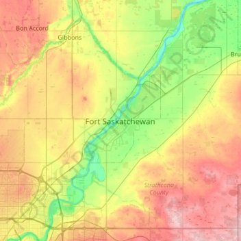
Name: Fort Saskatchewan topographic map, elevation, terrain.
Location: Fort Saskatchewan, Alberta, T8L 1Y8, Canada (53.55297 -113.37411 53.87297 -113.05411)
Average elevation: 2,172 ft
Minimum elevation: 1,939 ft
Maximum elevation: 2,490 ft
Other topographic maps
Click on a map to view its topography, its elevation and its terrain.
William Casey Park
Canada > Alberta > Fort Saskatchewan
William Casey Park, Fort Saskatchewan, Alberta, Canada
Average elevation: 2,047 ft