
Neyyatinkara topographic map
Interactive map
Click on the map to display elevation.
About this map
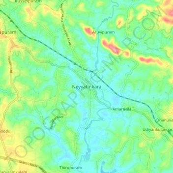
Name: Neyyatinkara topographic map, elevation, terrain.
Average elevation: 125 ft
Minimum elevation: 16 ft
Maximum elevation: 387 ft
Neyyattinkara is located at 8°24′N 77°05′E / 8.4°N 77.08°E / 8.4; 77.08. It has an average elevation of 26 metres (85 feet). The town is situated on the Neyyar River side, one of the principal rivers in Trivandrum district. The river flows to the south part of the town. Water Supply for the town and the adjacent places is obtained from this river. Topography of the town is rather uneven, with higher areas in the downtown. Nearby the town is the hillock Aruvippuram. The Western Ghats form a scenic backdrop to the town. The town is sandwiched between the Western Ghats and the Arabian Sea. The nearby sea shore is just 10 km. away in west, and seven kilometres to the east can take you to the mammoth hillocks of Western ghats. The geology is said to be typical of the Kerala soil - the Laterite and red soil. The town can still boast of a good green cover in residential and non-residential areas.
Other topographic maps
Click on a map to view its topography, its elevation and its terrain.
Poovar
India > Kerala > Neyyattinkara
Poovar, Neyyattinkara, Thiruvananthapuram, Kerala, 695525, India
Average elevation: 39 ft