
Aiguá topographic map
Interactive map
Click on the map to display elevation.
About this map
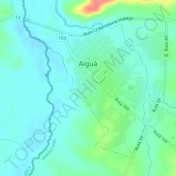
Name: Aiguá topographic map, elevation, terrain.
Location: Aiguá, Maldonado, 20500, Uruguay (-34.21644 -54.77915 -34.19496 -54.74746)
Average elevation: 312 ft
Minimum elevation: 266 ft
Maximum elevation: 482 ft
The municipality of Aiguá has the highest point of Uruguay, the Cerro Catedral. This point is situated at an altitude of 513.66 metres (1,685.2 ft).
Other topographic maps
Click on a map to view its topography, its elevation and its terrain.
Pinares - Las Delicias
Uruguay > Maldonado > Pinares - Las Delicias
Pinares - Las Delicias, Maldonado, 20005, Uruguay
Average elevation: 43 ft
Ocean Park
Uruguay > Maldonado > Ocean Park
Ocean Park, Maldonado, 20000, Uruguay
Average elevation: 46 ft
Piriápolis
Uruguay > Maldonado > Piriápolis
Piriápolis, Maldonado, 20200, Uruguay
Average elevation: 102 ft