
Huzhou topographic map
Interactive map
Click on the map to display elevation.
About this map
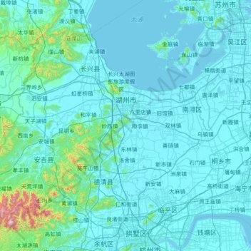
Name: Huzhou topographic map, elevation, terrain.
Location: Huzhou, Zhejiang, China (30.37562 119.23240 31.18258 120.48408)
Average elevation: 213 ft
Minimum elevation: -10 ft
Maximum elevation: 4,659 ft
Other topographic maps
Click on a map to view its topography, its elevation and its terrain.
Yandang Mountain Nanhe Archway Group
Yandang Mountain Nanhe Archway Group, 南閤村, Yueqing, Wenzhou, Zhejiang, 325616, China
Average elevation: 413 ft
大洲镇
China > Zhejiang > Qujiang District
大洲镇, Qujiang District, Quzhou, Zhejiang, China
Average elevation: 1,893 ft
Liucheng
China > Zhejiang > Wuyi County
Liucheng, Wuyi County, Jinhua, Zhejiang, China
Average elevation: 1,621 ft
Luqiao District
Luqiao District, Taizhou, Zhejiang, 318050, China
Average elevation: 210 ft
Pingyang County
China > Zhejiang > Pingyang County
Pingyang County, Wenzhou, Zhejiang, China
Average elevation: 541 ft
Yuecheng District
Yuecheng District, Shaoxing, Zhejiang, 312000, China
Average elevation: 148 ft
North Peak
China > Zhejiang > Xihu District
North Peak, Xihu District, Zhejiang, 310013, China
Average elevation: 361 ft