
Mārahau River topographic map
Interactive map
Click on the map to display elevation.
About this map
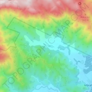
Name: Mārahau River topographic map, elevation, terrain.
Location: Mārahau River, Tasman, 7197, New Zealand (-40.99798 172.94753 -40.97375 173.01020)
Average elevation: 817 ft
Minimum elevation: 0 ft
Maximum elevation: 2,477 ft
Other topographic maps
Click on a map to view its topography, its elevation and its terrain.
Dragons Teeth
New Zealand > Tasman > Tasman District
Dragons Teeth, Tasman District, Tasman, New Zealand
Average elevation: 3,983 ft
Saint Arnaud
New Zealand > Tasman > Saint Arnaud
Saint Arnaud, Tasman, 7053, New Zealand
Average elevation: 2,300 ft
Wakefield
New Zealand > Tasman > Wakefield
Wakefield, Tasman, 7025, New Zealand
Average elevation: 440 ft