
Högvålen topographic map
Interactive map
Click on the map to display elevation.
About this map
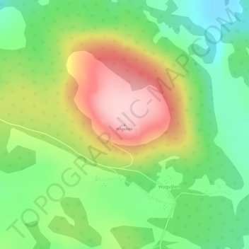
Name: Högvålen topographic map, elevation, terrain.
Average elevation: 2,733 ft
Minimum elevation: 2,457 ft
Maximum elevation: 3,100 ft
Other topographic maps
Click on a map to view its topography, its elevation and its terrain.
Frösön
Sweden > Jämtland County > Östersund
Frösön, Östersund, Jämtland County, Region Norrland, Sweden
Average elevation: 1,040 ft
Åreskutan
Åreskutan, Åre, Jämtland County, Region Norrland, 83752, Sweden
Average elevation: 3,658 ft
Havsnäs
Sweden > Jämtland County > Havsnäs
Havsnäs, Strömsund, Jämtland County, Region Norrland, Sweden
Average elevation: 1,014 ft