
Maymana topographic map
Interactive map
Click on the map to display elevation.
About this map
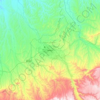
Name: Maymana topographic map, elevation, terrain.
Location: Maymana, Faryab, Afghanistan (35.76039 64.62225 36.08039 64.94225)
Average elevation: 3,245 ft
Minimum elevation: 1,972 ft
Maximum elevation: 6,142 ft
Maymana is located at the northern foot of the Torkestan Range at an elevation of 877 m (2,877 ft) on the old terrace of the Qeysar or Maymana River, which is a right tributary of the Murghab River. The Maymana River branches off of the Band-e Turkistan River 50 km south of the city. The highlands of the Maymana region generally possess a very rich topsoil which supports the seasonal agricultural activities.