
Enuahrat topographic map
Interactive map
Click on the map to display elevation.
About this map
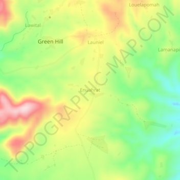
Name: Enuahrat topographic map, elevation, terrain.
Location: Enuahrat, Tafea, Vanuatu (-19.40850 169.28735 -19.36850 169.32735)
Average elevation: 899 ft
Minimum elevation: 446 ft
Maximum elevation: 1,430 ft
Other topographic maps
Click on a map to view its topography, its elevation and its terrain.
TAFEA Provincial Disaster Committee
TAFEA Provincial Disaster Committee, Nakepau, Lénakel, Tafea, Vanuatu
Average elevation: 240 ft