
Lac Gagnon topographic map
Interactive map
Click on the map to display elevation.
About this map
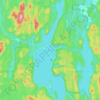
Name: Lac Gagnon topographic map, elevation, terrain.
Location: Lac Gagnon, Duhamel, Papineau, Outaouais, Québec, Canada (46.06954 -75.14561 46.18827 -75.09040)
Average elevation: 876 ft
Minimum elevation: 673 ft
Maximum elevation: 1,532 ft
Other topographic maps
Click on a map to view its topography, its elevation and its terrain.
Petit lac Preston
Canada > Québec > Papineau > Duhamel
Petit lac Preston, Duhamel, Papineau, Outaouais, Québec, Canada
Average elevation: 866 ft
Lac Saint-Ange
Canada > Québec > Papineau > Duhamel
Lac Saint-Ange, Duhamel, Papineau, Outaouais, Québec, Canada
Average elevation: 912 ft