
Beilstein topographic map
Interactive map
Click on the map to display elevation.
About this map
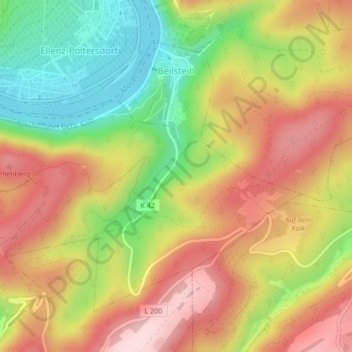
Name: Beilstein topographic map, elevation, terrain.
Average elevation: 768 ft
Minimum elevation: 262 ft
Maximum elevation: 1,217 ft
Other topographic maps
Click on a map to view its topography, its elevation and its terrain.
Pünderich
Germany > Rhineland-Palatinate > Landkreis Cochem-Zell
Pünderich, Zell (Mosel), Landkreis Cochem-Zell, Rhineland-Palatinate, 56862, Germany
Average elevation: 548 ft
Senheim
Germany > Rhineland-Palatinate > Landkreis Cochem-Zell > Senheim
Senheim, Cochem, Landkreis Cochem-Zell, Rhineland-Palatinate, Germany
Average elevation: 951 ft