
Bijie topographic map
Interactive map
Click on the map to display elevation.
About this map
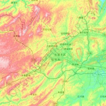
Name: Bijie topographic map, elevation, terrain.
Location: Bijie, Qixingguan, Bijie, Guizhou, 551700, China (27.12586 105.12660 27.44586 105.44660)
Average elevation: 5,417 ft
Minimum elevation: 4,331 ft
Maximum elevation: 7,080 ft
Bijie borders Zunyi to the east, Anshun and Liupanshui to the south, Zhaotong and Qujing (Yunnan) to the west, and Luzhou (Sichuan) to the north. It spans latitude 26°21′−27°46′ N and longitude 105°36′−106°43′ E, and is marked heavily by the presence of the Wumeng Mountains (乌蒙山) as well as karst topography. The Wu, Beipan, and Chishui Rivers are the most important rivers that originate here. The highest elevation is Jiucaiping (韭菜坪), at 2,900.6 m (9,516 ft), on the border of Hezhang and Weining counties.
Other topographic maps
Click on a map to view its topography, its elevation and its terrain.
Tianping
China > Guizhou > Yuping Dong Autonomous County
Tianping, Yuping Dong Autonomous County, Tongren, Guizhou, 558000, China
Average elevation: 1,946 ft
Daxing
China > Guizhou > Songtao Miao Autonomous County > Daxing
Daxing, Songtao Miao Autonomous County, Tongren, Guizhou, 558000, China
Average elevation: 2,182 ft
Daba
China > Guizhou > Zunyi City > Daba
Daba, Renhuai City, Zunyi City, Guizhou, China
Average elevation: 2,812 ft
Shuiyao
China > Guizhou > Libo County > Shuiyao
Shuiyao, Libo County, Qiannan Buyei and Miao Autonomous Prefecture, Guizhou, 558000, China
Average elevation: 2,454 ft
Xiazhai
China > Guizhou > Zunyi City > Xiazhai
Xiazhai, Bozhou District, Zunyi City, Guizhou, China
Average elevation: 2,648 ft
Qianxinan Buyei and Miao Autonomous Prefecture
Qianxinan, Huangcao, Xingyi City, Qianxinan Buyei and Miao Autonomous Prefecture, Guizhou, China
Average elevation: 4,101 ft