
South Oxfordshire topographic map
Interactive map
Click on the map to display elevation.
About this map
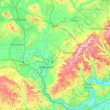
Name: South Oxfordshire topographic map, elevation, terrain.
Location: South Oxfordshire, Oxfordshire, England, United Kingdom (51.45941 -1.29024 51.81377 -0.87007)
Average elevation: 318 ft
Minimum elevation: 92 ft
Maximum elevation: 853 ft
Other topographic maps
Click on a map to view its topography, its elevation and its terrain.
Goring-on-Thames
United Kingdom > England > Oxfordshire > South Oxfordshire
Goring-on-Thames, South Oxfordshire, Oxfordshire, England, RG8 0EB, United Kingdom
Average elevation: 276 ft
Sonning Common
United Kingdom > England > Oxfordshire > South Oxfordshire > Sonning Common
Sonning Common, South Oxfordshire, Oxfordshire, England, United Kingdom
Average elevation: 289 ft
Goring-on-Thames
United Kingdom > England > Oxfordshire > South Oxfordshire
Goring-on-Thames, South Oxfordshire, Oxfordshire, England, United Kingdom
Average elevation: 285 ft
Britwell Salome
United Kingdom > England > Oxfordshire > South Oxfordshire
Britwell Salome, South Oxfordshire, Oxfordshire, England, United Kingdom
Average elevation: 404 ft
Sonning Eye
United Kingdom > England > Oxfordshire > South Oxfordshire > Dunsden Green
Sonning Eye, Eye and Dunsden, Dunsden Green, South Oxfordshire, Oxfordshire, England, RG4 6TN, United Kingdom
Average elevation: 167 ft
Dorchester On Thames
United Kingdom > England > Oxfordshire > South Oxfordshire
Dorchester On Thames, South Oxfordshire, Oxfordshire, England, OX10 7HH, United Kingdom
Average elevation: 177 ft
North Moreton
United Kingdom > England > Oxfordshire > South Oxfordshire
North Moreton, South Oxfordshire, Oxfordshire, England, United Kingdom
Average elevation: 197 ft
Cholsey
United Kingdom > England > Oxfordshire > South Oxfordshire
Cholsey, South Oxfordshire, Oxfordshire, England, United Kingdom
Average elevation: 220 ft
Thame
United Kingdom > England > Oxfordshire > South Oxfordshire
Thame, South Oxfordshire, Oxfordshire, England, United Kingdom
Average elevation: 243 ft
Didcot
United Kingdom > England > Oxfordshire > South Oxfordshire
Didcot, South Oxfordshire, Oxfordshire, England, United Kingdom
Average elevation: 200 ft
Woodcote
United Kingdom > England > Oxfordshire > South Oxfordshire
Woodcote, South Oxfordshire, Oxfordshire, England, United Kingdom
Average elevation: 446 ft
Wallingford
United Kingdom > England > Oxfordshire > South Oxfordshire > Crowmarsh Gifford
Wallingford, Crowmarsh Gifford, South Oxfordshire, Oxfordshire, England, United Kingdom
Average elevation: 167 ft
Milton Common
United Kingdom > England > Oxfordshire > South Oxfordshire
Milton Common, Great Milton, South Oxfordshire, Oxfordshire, England, OX9 2NS, United Kingdom
Average elevation: 266 ft
Henley-on-Thames
United Kingdom > England > Oxfordshire > South Oxfordshire
Henley-on-Thames, South Oxfordshire, Oxfordshire, England, RG9 2AN, United Kingdom
Average elevation: 256 ft