
Otamiri River topographic map
Interactive map
Click on the map to display elevation.
About this map
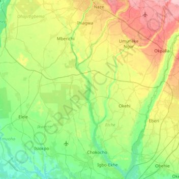
Name: Otamiri River topographic map, elevation, terrain.
Location: Otamiri River, Etche, Rivers, 460242, Nigeria (4.90405 6.96606 5.47345 7.14204)
Average elevation: 144 ft
Minimum elevation: 3 ft
Maximum elevation: 456 ft
Other topographic maps
Click on a map to view its topography, its elevation and its terrain.
Alonchia-Igobama
Nigeria > Rivers > Alonchia-Igobama
Alonchia-Igobama, Okrika, Rivers, Nigeria
Average elevation: 30 ft
Imogwu-Agwa
Nigeria > Rivers > Imogwu-Agwa
Imogwu-Agwa, Ikwerre, Rivers, Nigeria
Average elevation: 72 ft