
Djibouti topographic map
Interactive map
Click on the map to display elevation.
About this map
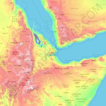
Name: Djibouti topographic map, elevation, terrain.
Location: Djibouti (4.31460 35.34531 19.31460 50.34531)
Average elevation: 2,677 ft
Minimum elevation: -404 ft
Maximum elevation: 14,045 ft
Djibouti is situated in the Horn of Africa on the Gulf of Aden and the Bab-el-Mandeb, at the southern entrance to the Red Sea. It lies between latitudes 11° and 14°N and longitudes 41° and 44°E, at the northernmost point of the Great Rift Valley. It is here in Djibouti that the rift between the African Plate and the Somali Plate meet the Arabian Plate, forming a geologic tripoint. The tectonic interaction at this tripoint has created the lowest elevation of any place in Africa, and indeed, the second lowest depression on dry land found anywhere on earth (surpassed only by the depression along the border of Jordan and Israel).
Other topographic maps
Click on a map to view its topography, its elevation and its terrain.
Rahra
Djibouti > Obock > Obock District
Rahra, Obock District, Obock, Djibouti
Average elevation: 2,464 ft
Balbala بلبالا
Djibouti > Djibouti > Balbala بلبالا
Balbala بلبالا, Djibouti, الشيخ موسى, Djibouti
Average elevation: 112 ft
Lake Assal
Lake Assal, مسار درة-بالهو / Piste Dorra - Balho, Dorra, Balha District, Tadjourah, Djibouti
Average elevation: -436 ft