
Nakhon Phanom Province topographic map
Interactive map
Click on the map to display elevation.
About this map
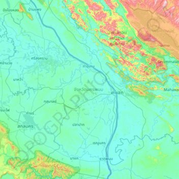
Name: Nakhon Phanom Province topographic map, elevation, terrain.
Location: Nakhon Phanom Province, Thailand (16.80538 103.98637 18.02484 104.80661)
Average elevation: 784 ft
Minimum elevation: 433 ft
Maximum elevation: 3,527 ft
Other topographic maps
Click on a map to view its topography, its elevation and its terrain.
Na Wa
Thailand > Nakhon Phanom Province > Na Wa
Na Wa, Nakhon Phanom Province, Thailand
Average elevation: 505 ft