
Clyde River topographic map
Interactive map
Click on the map to display elevation.
About this map
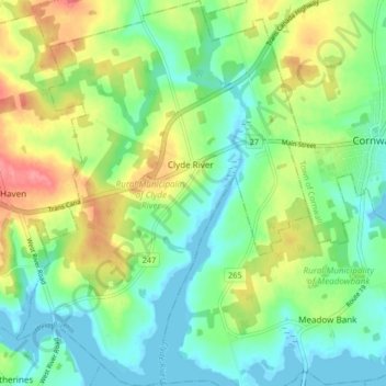
Name: Clyde River topographic map, elevation, terrain.
Average elevation: 89 ft
Minimum elevation: -10 ft
Maximum elevation: 243 ft
The Stone House was built from Island sandstone in 1842, located adjacent to the Trans Canada High Way in Clyde River, PEI. In 1843, the property was purchased by Ambrose Lane and the house was used as hunting lodge. After the passing of the owner in 1853, the house had various owners. In the 1970s the house was purchase by the Atwell family. Now the Stone House is referred to as the Atwell House. The house is one of eight remaining sandstone homes that were constructed in the 1800s. The house is unique because if the 21 inch cavity walls, the size and placement of the windows and doors, the Island sandstone construction, the interior arrangement of rooms and the dormer of the front elevation. Today the Wood family resides in the Stone House.
Other topographic maps
Click on a map to view its topography, its elevation and its terrain.
Dunedin
Canada > Prince Edward Island > Rural Municipality of Clyde River > Clyde River
Dunedin, Clyde River, Rural Municipality of Clyde River, Queens County, Prince Edward Island, C0A 1H7, Canada
Average elevation: 72 ft