
Girdwood topographic map
Interactive map
Click on the map to display elevation.
About this map
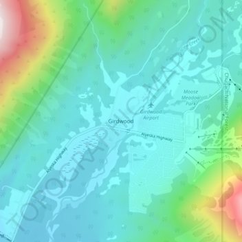
Name: Girdwood topographic map, elevation, terrain.
Location: Girdwood, Anchorage, Alaska, 99587, United States (60.94325 -149.15370 60.98325 -149.11370)
Average elevation: 594 ft
Minimum elevation: 23 ft
Maximum elevation: 3,209 ft
Other topographic maps
Click on a map to view its topography, its elevation and its terrain.
Redoubt
United States > Alaska > Anchorage
Redoubt, Anchorage, Alaska, United States
Average elevation: 161 ft
Anchorage
United States > Alaska > Anchorage
Anchorage, Alaska, 99501, United States
Average elevation: 407 ft
Chugiak
United States > Alaska > Anchorage
Chugiak, Anchorage, Alaska, United States
Average elevation: 968 ft
Chugach Meadows
United States > Alaska > Anchorage > Anchorage
Chugach Meadows, Anchorage, Alaska, United States
Average elevation: 151 ft
Alyeska
United States > Alaska > Anchorage > Girdwood
Alyeska, Girdwood, Anchorage, Alaska, 99523, United States
Average elevation: 840 ft
South Yuyanq’ Ch’ex
United States > Alaska > Anchorage
South Yuyanq’ Ch’ex, Anchorage, Alaska, United States
Average elevation: 3,514 ft
Knik Arm
United States > Alaska > Anchorage
Knik Arm, Anchorage, Alaska, United States
Average elevation: 236 ft
Powder Ridge
United States > Alaska > Anchorage
Powder Ridge, Anchorage, Alaska, United States
Average elevation: 292 ft