
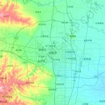
Anyang topographic map
Interactive map
Click on the map to display elevation.
About this map
Name: Anyang topographic map, elevation, terrain.
Location: Anyang, Beiguan District, Anyang City, Henan, China (35.94236 114.17633 36.26236 114.49633)
Average elevation: 335 ft
Minimum elevation: 184 ft
Maximum elevation: 902 ft
Anyang spans a total area of 7,355 square kilometres (2,840 sq mi). The city's elevation is generally higher in the west, with the foothills of the Taihang Mountains running through the area, and lower in the east, which comprises part of the North China Plain.
Other topographic maps
Click on a map to view its topography, its elevation and its terrain.
Fuwa
China > Henan > Shangcheng County > Duntangcun
Fuwa, Duntangcun, Shangcheng County, Xinyang, Henan, China
Average elevation: 466 ft
Cuiyunlu Subdistrict
China > Henan > Luolong District
Cuiyunlu Subdistrict, Luolong District, Luoyang, Henan, China
Average elevation: 486 ft
Bao River
China > Henan > Shangqiu City
Bao River, Shangqiu City, Henan, China
Average elevation: 115 ft
Xichuan
China > Henan > Xichuan County > Xichuan
Xichuan, Xichuan County, Nanyang City, Henan, China
Average elevation: 1,073 ft
Suiping County
China > Henan > Suiping County > Zhumadian City
Suiping County, Zhumadian City, Henan, China
Average elevation: 299 ft
Mangshan Subdistrict
China > Henan > Mangshan Subdistrict
Mangshan Subdistrict, Laocheng District, Luoyang City, Henan, China
Average elevation: 709 ft