
Xi'an topographic map
Interactive map
Click on the map to display elevation.
About this map
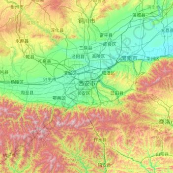
Name: Xi'an topographic map, elevation, terrain.
Location: Xi'an, Shaanxi, China (33.69522 107.65562 34.74595 109.79144)
Average elevation: 3,196 ft
Minimum elevation: 1,089 ft
Maximum elevation: 9,810 ft
Other topographic maps
Click on a map to view its topography, its elevation and its terrain.
Lintong District
Lintong District, Xi'an, Shaanxi, 710600, China
Average elevation: 1,519 ft
Baihe County
China > Shaanxi > Ankang City
Baihe County, Ankang City, Shaanxi, China
Average elevation: 2,493 ft