
Piedrafita topographic map
Interactive map
Click on the map to display elevation.
About this map
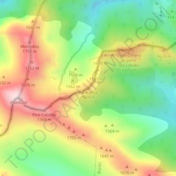
Name: Piedrafita topographic map, elevation, terrain.
Location: Piedrafita, Ponga, Asturias, 24996, España (43.09408 -5.19191 43.09418 -5.19181)
Average elevation: 4,987 ft
Minimum elevation: 4,232 ft
Maximum elevation: 5,906 ft
Other topographic maps
Click on a map to view its topography, its elevation and its terrain.
Parque Natural de Ponga
Parque Natural de Ponga, Carretera Beleño - Los Beyos, Ponga, Asturias, 33558, España
Average elevation: 3,340 ft