
Tilburg topographic map
Interactive map
Click on the map to display elevation.
About this map
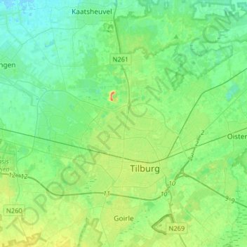
Name: Tilburg topographic map, elevation, terrain.
Location: Tilburg, North Brabant, Netherlands (51.52950 4.94785 51.64166 5.21071)
Average elevation: 36 ft
Minimum elevation: -3 ft
Maximum elevation: 125 ft
In the 1980s, many locations, formerly occupied by wool factories had been filled with small-scale housing projects. This mostly happened when Henk Letschert was mayor of Tilburg.[14] The Heuvel, one of the important squares, had its own lime tree until 27 April 1994, being chopped for a bicycle parking basement. The felling led to many protests, because the tree was still healthy. After the Pieter Vreedeplein reconstruction, plans were made to plant a descendant of the original lime tree. Three were placed, only one of them survived. The last living tree was moved to another location again,[15] but died shortly after. As of 23 November 2011, no more descendants have been placed. The current one is just another lime tree.[16] In the 1990s Tilburg developed a modern skyline. Because of new policy three buildings were built, which are considered skyscrapers in the Netherlands. These are the Interpolis headquarters, the Westpoint Tower and StadsHeer. The Westpoint Tower has an altitude of 143.1 metres (469.5 feet) and was the tallest residential tower in The Netherlands until the Montevideo in Rotterdam surpassed it. The 'StadsHeer' is the third one and is part of the 'Haestrechtkwartier' (Haestrecht quarter). The residential tower is nicknamed De Vogelkooikes (The Bird Cages) for its cubic balconies taped[clarification needed] onto the building.
Other topographic maps
Click on a map to view its topography, its elevation and its terrain.
Geldrop
Geldrop, Geldrop-Mierlo, North Brabant, Netherlands
Average elevation: 69 ft
Berkhoek
Netherlands > North Brabant > Udenhout
Berkhoek, Udenhout, Tilburg, North Brabant, Netherlands, 5071 NE, Netherlands
Average elevation: 36 ft
Maaskantje
Maaskantje, Sint-Michielsgestel, North Brabant, Netherlands, 5271 XG, Netherlands
Average elevation: 20 ft
Gilze
Gilze, Gilze en Rijen, North Brabant, Netherlands
Average elevation: 49 ft
Everland
Netherlands > North Brabant > Nispen
Everland, Nispen, Roosendaal, North Brabant, Netherlands, 4709 RM, Netherlands
Average elevation: 26 ft
Willemstad
Willemstad, Moerdijk, North Brabant, Netherlands
Average elevation: 0 ft
Kloostereind
Netherlands > North Brabant > Helmond
Kloostereind, Helmond, North Brabant, Netherlands, 5704 BK, Netherlands
Average elevation: 69 ft
Boxmeer
Boxmeer, Land van Cuijk, North Brabant, Netherlands
Average elevation: 46 ft
Terheijden
Netherlands > North Brabant > Terheijden
Terheijden, Drimmelen, North Brabant, Netherlands
Average elevation: 3 ft
Eethen
Netherlands > North Brabant > Eethen
Eethen, Altena, North Brabant, Netherlands
Average elevation: 3 ft
Eindhoven
Netherlands > North Brabant > Eindhoven
Eindhoven, North Brabant, Netherlands, 5611EB, Netherlands
Average elevation: 69 ft
Eind
Netherlands > North Brabant > Riethoven
Eind, Riethoven, Bergeijk, North Brabant, Netherlands, 5561 BC, Netherlands
Average elevation: 89 ft
Werveld
Netherlands > North Brabant > Oeffelt > Oeffelt > Werveld
Werveld, Oeffelt, Land van Cuijk, North Brabant, Netherlands, 5441, Netherlands
Average elevation: 39 ft
Dommelen
Netherlands > North Brabant > Valkenswaard > Dommelen
Dommelen, Valkenswaard, North Brabant, Netherlands, 5551DE, Netherlands
Average elevation: 82 ft
Goirle
Netherlands > North Brabant > Goirle
Goirle, North Brabant, Netherlands
Average elevation: 59 ft
Wanroij
Netherlands > North Brabant > Wanroij > Wanroij
Wanroij, Land van Cuijk, North Brabant, Netherlands, 5446, Netherlands
Average elevation: 49 ft
Eerde
Netherlands > North Brabant > Veghel > Eerde
Eerde, Veghel, Meierijstad, North Brabant, Netherlands, 5466, Netherlands
Average elevation: 36 ft
Langenboom
Netherlands > North Brabant > Langenboom > Langenboom
Langenboom, Land van Cuijk, North Brabant, Netherlands, 5453, Netherlands
Average elevation: 59 ft
Ulvenhout
Ulvenhout, Breda, North Brabant, Netherlands
Average elevation: 20 ft
Tilburg
Netherlands > North Brabant > Tilburg
Tilburg, North Brabant, Netherlands
Average elevation: 39 ft
Dassemus
Netherlands > North Brabant > Chaam
Dassemus, Chaam, Alphen-Chaam, North Brabant, Netherlands, 4861 TG, Netherlands
Average elevation: 36 ft
Middelbeers
Middelbeers, Oost West en Middelbeers, Oirschot, North Brabant, Netherlands, 5091 CB, Netherlands
Average elevation: 62 ft
Sint-Michielsgestel
Sint-Michielsgestel, North Brabant, Netherlands
Average elevation: 20 ft
Bergen op Zoom
Bergen op Zoom, North Brabant, Netherlands
Average elevation: 16 ft
Boxtel
Netherlands > North Brabant > Boxtel
Boxtel, North Brabant, Netherlands
Average elevation: 26 ft
Sint-Oedenrode
Netherlands > North Brabant > Meierijstad
Sint-Oedenrode, Meierijstad, North Brabant, Netherlands
Average elevation: 39 ft
Drunen
Netherlands > North Brabant > Heusden
Drunen, Heusden, North Brabant, Netherlands
Average elevation: 20 ft
's-Hertogenbosch
's-Hertogenbosch, North Brabant, Netherlands
Average elevation: 13 ft
Doeveren
Netherlands > North Brabant > Heusden
Doeveren, Heusden, North Brabant, Netherlands
Average elevation: 3 ft
Veldhoven
Netherlands > North Brabant > Veldhoven
Veldhoven, Eersel, North Brabant, Netherlands
Average elevation: 75 ft
Heusden
Netherlands > North Brabant > Heusden
Heusden, North Brabant, Netherlands
Average elevation: 13 ft
Valkenswaard
Valkenswaard, North Brabant, Netherlands
Average elevation: 95 ft
Sleeuwijk
Netherlands > North Brabant > Altena
Sleeuwijk, Altena, North Brabant, Netherlands
Average elevation: 3 ft
Landerd
Netherlands > North Brabant > Landerd
Landerd, North Brabant, Netherlands
Average elevation: 52 ft
Mill
Mill, Land van Cuijk, North Brabant, Netherlands
Average elevation: 46 ft