
Roatán topographic map
Interactive map
Click on the map to display elevation.
About this map
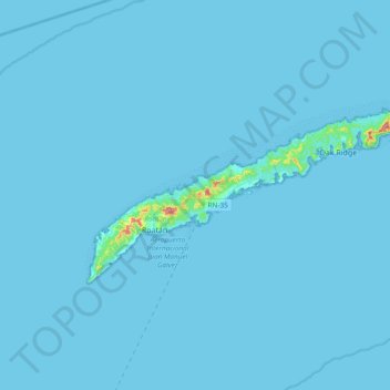
Name: Roatán topographic map, elevation, terrain.
Location: Roatán, Coxen Hole, Roatan, Bay Islands, 33166, Honduras (16.26676 -86.60303 16.43131 -86.26127)
Average elevation: 10 ft
Minimum elevation: -3 ft
Maximum elevation: 715 ft
Other topographic maps
Click on a map to view its topography, its elevation and its terrain.
Útila
Honduras > Bay Islands > Coxen Hole
Útila, Coxen Hole, Bay Islands, THE BAY ISLANDS, Honduras
Average elevation: 3 ft