
Arnedo topographic map
Interactive map
Click on the map to display elevation.
About this map
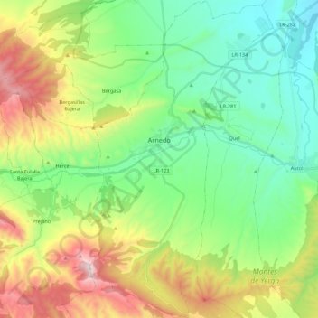
Name: Arnedo topographic map, elevation, terrain.
Location: Arnedo, La Rioja, 26580, España (42.13749 -2.14663 42.29774 -2.02162)
Average elevation: 2,313 ft
Minimum elevation: 1,125 ft
Maximum elevation: 4,760 ft
El término municipal de Arnedo tiene 86,8 km² que se extienden a ambas márgenes del río, aunque su núcleo urbano se halla en la izquierda del mismo. Incluye desde 1975 el anterior municipio de Turruncún, hoy deshabitado. Su altitud media sobre el nivel del mar es de 523 m, que marcan el comienzo de la sierra hacia el sur.
Other topographic maps
Click on a map to view its topography, its elevation and its terrain.