
Varanasi topographic map
Interactive map
Click on the map to display elevation.
About this map
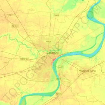
Name: Varanasi topographic map, elevation, terrain.
Average elevation: 253 ft
Minimum elevation: 180 ft
Maximum elevation: 315 ft
Varanasi is located at an elevation of 80.71 metres (264.8 ft) in the centre of the Ganges valley of North India, in the Eastern part of the state of Uttar Pradesh, along the left crescent-shaped bank of the Ganges, averaging between 15 metres (50 ft) and 21 metres (70 ft) above the river. The city is the headquarters of Varanasi district. By road, Varanasi is located 797 kilometres (495 mi) south-east of New Delhi, 320 kilometres (200 mi) south-east of Lucknow, 121 kilometres (75 mi) east of Allahabad, and 63 kilometres (39 mi) south of Jaunpur. The "Varanasi Urban Agglomeration" – an agglomeration of seven urban sub-units – covers an area of 112 km2 (43 sq mi). Neighbourhoods of the city include Adampura, Anandbagh, Bachchhaon, Bangali Tola, Bhelpura, Bulanala, Chaitganj, Chaukaghat, Chowk, Dhupchandi, Dumraon, Gandhinagar, Gautam Nagar, Giri Nagar, Gopal Vihar, Guru Nanak Nagar, Jaitpura, Kail Garh, Khanna, Kotwali, Lanka Manduadih, Luxa, Maheshpur, Mahmoorganj, Maulvibagh, Nagwar, Naipokhari, Shivala, Siddhagiribagh, and Sigra.
Other topographic maps
Click on a map to view its topography, its elevation and its terrain.
Sarnath
India > Uttar Pradesh > Sadar
Sarnath, Sadar, Varanasi, Uttar Pradesh, 221007, India
Average elevation: 256 ft