
Chamoli Gopeshwar topographic map
Interactive map
Click on the map to display elevation.
About this map
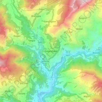
Name: Chamoli Gopeshwar topographic map, elevation, terrain.
Location: Chamoli Gopeshwar, Chamoli, Uttarakhand, 246401, India (30.36878 79.27855 30.44878 79.35855)
Average elevation: 5,138 ft
Minimum elevation: 2,936 ft
Maximum elevation: 8,940 ft
Gopeshwar is located at 30°25′N 79°20′E / 30.42°N 79.33°E / 30.42; 79.33. It has an average elevation of 1,550 m (5,090 ft). Gopeshwar is 8.4 km (5.2 mi) away from Chamoli which is located on the banks of Alaknanda river and along NH 58. Gopeshwar is able to captivate any visitor with its mystic charm and pristine beauty. There are multiple snow-capped hills and peaks visible from Gopeshwar.