
Tawang topographic map
Interactive map
Click on the map to display elevation.
About this map
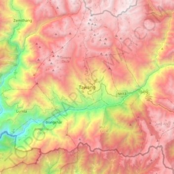
Name: Tawang topographic map, elevation, terrain.
Average elevation: 10,761 ft
Minimum elevation: 3,839 ft
Maximum elevation: 16,119 ft
Tawang is situated 448 km north-west of state capital Itanagar at an elevation of approximately 3,048 metres (10,000 ft). It lies to the north of the Tawang Chu river valley, roughly 10 miles (16 km) south of the Line of Actual Control with China. It is the site of a famous Gelugpa Buddhist monastery.
Other topographic maps
Click on a map to view its topography, its elevation and its terrain.
Jang
India > Arunachal Pradesh > Tawang Circle
Jang, Tawang Circle, Tawang district, Arunachal Pradesh, India
Average elevation: 8,432 ft