
Rotorua topographic map
Interactive map
Click on the map to display elevation.
About this map
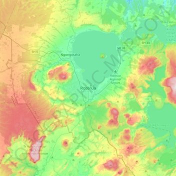
Name: Rotorua topographic map, elevation, terrain.
Average elevation: 1,427 ft
Minimum elevation: 705 ft
Maximum elevation: 2,822 ft
Other topographic maps
Click on a map to view its topography, its elevation and its terrain.
Lake Rotoiti / Te Roto kite ā Ihenga i ariki ai Kahu
New Zealand > Bay of Plenty > Rotorua Lakes District > Okere Falls
Lake Rotoiti / Te Roto kite ā Ihenga i ariki ai Kahu, Okere Falls, Rotorua Lakes District, Bay of Plenty, New Zealand
Average elevation: 1,230 ft
Lake Okaro
New Zealand > Bay of Plenty > Rotorua Lakes District
Lake Okaro, Rotorua Lakes District, Bay of Plenty, New Zealand
Average elevation: 1,391 ft
Hamurana
New Zealand > Bay of Plenty > Rotorua Lakes District
Hamurana, Rotorua Lakes District, Bay of Plenty, 3096, New Zealand
Average elevation: 1,086 ft
Kaingaroa Forest
New Zealand > Bay of Plenty > Rotorua Lakes District
Kaingaroa Forest, Rotorua Lakes District, Bay of Plenty, New Zealand
Average elevation: 1,709 ft
Lake Rotorua
New Zealand > Bay of Plenty > Rotorua Lakes District > Hamurana
Lake Rotorua, Hamurana, Rotorua Lakes District, Bay of Plenty, 3040, New Zealand
Average elevation: 981 ft
Ngongotaha
New Zealand > Bay of Plenty > Rotorua Lakes District
Ngongotaha, Rotorua Lakes District, Bay of Plenty, New Zealand
Average elevation: 1,112 ft
Lake Rotomahana
New Zealand > Bay of Plenty > Rotorua Lakes District
Lake Rotomahana, Rotorua Lakes District, Bay of Plenty, New Zealand
Average elevation: 1,201 ft
Lake Tarawera
New Zealand > Bay of Plenty > Rotorua Lakes District > Lake Tarawera
Lake Tarawera, Rotorua Lakes District, Bay of Plenty, New Zealand
Average elevation: 1,293 ft
Lake Okareka
New Zealand > Bay of Plenty > Rotorua Lakes District
Lake Okareka, Rotorua Lakes District, Bay of Plenty, New Zealand
Average elevation: 1,447 ft
Te Ngae
New Zealand > Bay of Plenty > Rotorua Lakes District > Tikitere
Te Ngae, Tikitere, Rotorua Lakes District, Bay of Plenty, New Zealand
Average elevation: 1,004 ft
Lake Rotoehu
New Zealand > Bay of Plenty > Rotorua Lakes District
Lake Rotoehu, Rotorua Lakes District, Bay of Plenty, New Zealand
Average elevation: 1,066 ft
Lake Ōkataina / Te Moana i kataina ā Te Rangitakaroro
New Zealand > Bay of Plenty > Rotorua Lakes District
Lake Ōkataina / Te Moana i kataina ā Te Rangitakaroro, Rotorua Lakes District, Bay of Plenty, New Zealand
Average elevation: 1,444 ft
Lake Rotokakahi
New Zealand > Bay of Plenty > Rotorua Lakes District > Rotorua
Lake Rotokakahi, Rotorua, Rotorua Lakes District, Bay of Plenty, New Zealand
Average elevation: 1,545 ft
Gisborne Point
New Zealand > Bay of Plenty > Rotorua Lakes District
Gisborne Point, Rotorua Lakes District, Bay of Plenty, New Zealand
Average elevation: 1,148 ft