
Queenstown topographic map
Interactive map
Click on the map to display elevation.
About this map
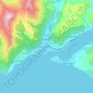
Name: Queenstown topographic map, elevation, terrain.
Average elevation: 1,942 ft
Minimum elevation: 994 ft
Maximum elevation: 5,673 ft
The town is at a relatively low altitude for a ski and snowboarding centre, at 310 metres (1,020 ft) above sea level at the lake shore, but is nestled among mountains, most notably the scenic attraction of The Remarkables, to the town's southeast. Below the lake lies the deep Kawarau Gorge, and there are nearby plains suitable for agriculture and viticulture. Queenstown lies close to the heart of the Central Otago wine region.
Other topographic maps
Click on a map to view its topography, its elevation and its terrain.
Wānaka
New Zealand > Otago > Queenstown-Lakes District
Wānaka, Queenstown-Lakes District, Otago, 9305, New Zealand
Average elevation: 1,250 ft
Kelvin Peninsula
New Zealand > Otago > Queenstown-Lakes District > Queenstown
Kelvin Peninsula, Kelvin Heights, Queenstown, Queenstown-Lakes District, Otago, 9300, New Zealand
Average elevation: 1,220 ft
Arrowtown
New Zealand > Otago > Queenstown-Lakes District
Arrowtown, Queenstown-Lakes District, Otago, 9302, New Zealand
Average elevation: 2,201 ft
Matukituki River
New Zealand > Otago > Queenstown-Lakes District
Matukituki River, Queenstown-Lakes District, Otago, New Zealand
Average elevation: 1,106 ft
Gibbston
New Zealand > Otago > Queenstown-Lakes District
Gibbston, Queenstown-Lakes District, Otago, New Zealand
Average elevation: 1,611 ft
Moke Lake
New Zealand > Otago > Queenstown-Lakes District
Moke Lake, Queenstown-Lakes District, Otago, New Zealand
Average elevation: 2,215 ft
Mount Iron
New Zealand > Otago > Queenstown-Lakes District > Wanaka
Mount Iron, Wanaka, Queenstown-Lakes District, Otago, 9305, New Zealand
Average elevation: 1,109 ft
Frankton Arm
New Zealand > Otago > Queenstown-Lakes District > Queenstown
Frankton Arm, Queenstown, Queenstown-Lakes District, Otago, 9300, New Zealand
Average elevation: 1,516 ft
Lake Hāwea
New Zealand > Otago > Queenstown-Lakes District
Lake Hāwea, Queenstown-Lakes District, Otago, New Zealand
Average elevation: 2,835 ft
Glenorchy
New Zealand > Otago > Queenstown-Lakes District
Glenorchy, Queenstown-Lakes District, Otago, 9372, New Zealand
Average elevation: 1,260 ft
Kingston
New Zealand > Otago > Queenstown-Lakes District
Kingston, Queenstown-Lakes District, Otago, New Zealand
Average elevation: 1,663 ft
Mount Creighton
New Zealand > Otago > Queenstown-Lakes District
Mount Creighton, Queenstown-Lakes District, Otago, New Zealand
Average elevation: 1,316 ft
Glendhu Bay
New Zealand > Otago > Queenstown-Lakes District > Glendhu Bay
Glendhu Bay, Queenstown-Lakes District, Otago, New Zealand
Average elevation: 1,332 ft
Lake Wānaka
New Zealand > Otago > Queenstown-Lakes District
Lake Wānaka, Queenstown-Lakes District, Otago, New Zealand
Average elevation: 2,664 ft
Dalefield
New Zealand > Otago > Queenstown-Lakes District
Dalefield, Queenstown-Lakes District, Otago, New Zealand
Average elevation: 1,558 ft