
Veurne topographic map
Interactive map
Click on the map to display elevation.
About this map
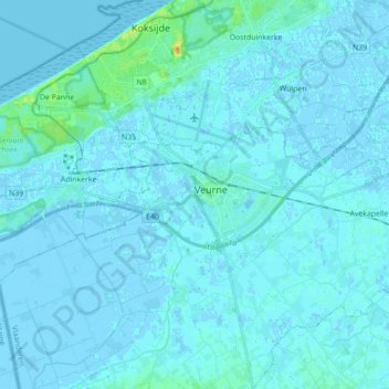
Name: Veurne topographic map, elevation, terrain.
Location: Veurne, West Flanders, Flanders, Belgium (51.05162 2.60082 51.09029 2.77687)
Average elevation: 7 ft
Minimum elevation: -13 ft
Maximum elevation: 89 ft
Other topographic maps
Click on a map to view its topography, its elevation and its terrain.
Bulskamp
Belgium > West Flanders > Veurne > Veurne
Bulskamp, Veurne, West Flanders, Flanders, 8630, Belgium
Average elevation: 3 ft
Beauvoorde
Belgium > West Flanders > Veurne > Veurne
Beauvoorde, Veurne, West Flanders, Flanders, 8630, Belgium
Average elevation: 16 ft