
Diksmuide topographic map
Interactive map
Click on the map to display elevation.
About this map
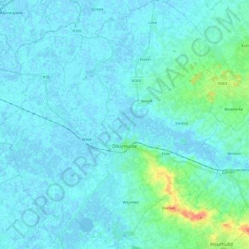
Name: Diksmuide topographic map, elevation, terrain.
Location: Diksmuide, West Flanders, Flanders, 8600, Belgium (50.97468 2.74311 51.11623 2.95133)
Average elevation: 16 ft
Minimum elevation: -10 ft
Maximum elevation: 138 ft
Other topographic maps
Click on a map to view its topography, its elevation and its terrain.
Kortemark
Belgium > West Flanders > Diksmuide
Kortemark, Diksmuide, West Flanders, 8610, Belgium
Average elevation: 59 ft
Beerst
Belgium > West Flanders > Diksmuide > Diksmuide
Beerst, Diksmuide, West Flanders, Flanders, 8600, Belgium
Average elevation: 10 ft