
Lamego topographic map
Interactive map
Click on the map to display elevation.
About this map
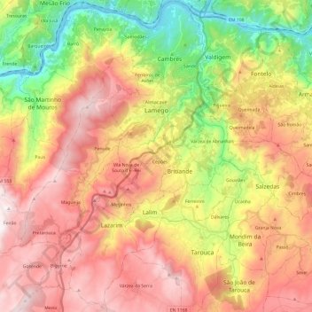
Name: Lamego topographic map, elevation, terrain.
Location: Lamego, Viseu, Portugal (40.98150 -7.91568 41.16187 -7.72997)
Average elevation: 2,077 ft
Minimum elevation: 144 ft
Maximum elevation: 3,950 ft
Other topographic maps
Click on a map to view its topography, its elevation and its terrain.
Adega do Chão
Adega do Chão, Cambres, Lamego, Viseu, 5100-381, Portugal
Average elevation: 584 ft