
Serpa topographic map
Interactive map
Click on the map to display elevation.
About this map
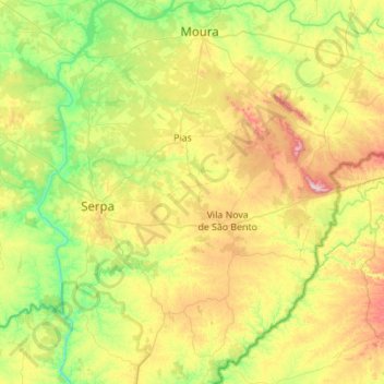
Name: Serpa topographic map, elevation, terrain.
Location: Serpa, Beja, Portugal (37.74120 -7.68233 38.17640 -7.24826)
Average elevation: 600 ft
Minimum elevation: 36 ft
Maximum elevation: 1,663 ft
Other topographic maps
Click on a map to view its topography, its elevation and its terrain.
Ribeira dos Lameiros
Ribeira dos Lameiros, São Luís, Odemira, Beja, Portugal
Average elevation: 351 ft
Corte Gafo de Cima
Portugal > Beja > Mértola > Corte Gafo de Cima
Corte Gafo de Cima, Mértola, Beja, 7750-308, Portugal
Average elevation: 545 ft