
Tavira topographic map
Interactive map
Click on the map to display elevation.
About this map
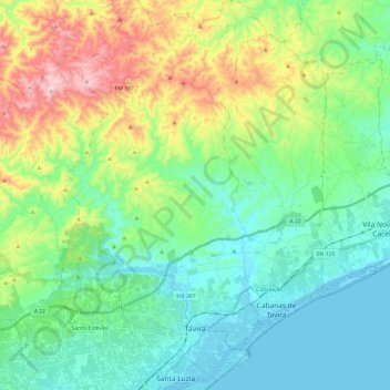
Name: Tavira topographic map, elevation, terrain.
Location: Tavira, Faro, Algarve, Portugal (37.09588 -7.73004 37.28783 -7.60608)
Average elevation: 531 ft
Minimum elevation: -3 ft
Maximum elevation: 1,699 ft
Other topographic maps
Click on a map to view its topography, its elevation and its terrain.
Corte Vidreiro
Portugal > Algarve > Tavira > Corte Vidreiro
Corte Vidreiro, Santa Catarina da Fonte do Bispo, Tavira, Faro, Algarve, 8800-164 TAVIRA, Portugal
Average elevation: 607 ft