
Rossum topographic map
Interactive map
Click on the map to display elevation.
About this map
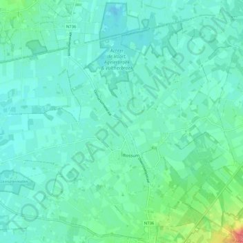
Name: Rossum topographic map, elevation, terrain.
Location: Rossum, Dinkelland, Overijssel, Nederland (52.32946 6.86770 52.39054 6.97093)
Average elevation: 89 ft
Minimum elevation: 49 ft
Maximum elevation: 262 ft
Other topographic maps
Click on a map to view its topography, its elevation and its terrain.
Deurningen
Nederland > Overijssel > Dinkelland
Deurningen, Dinkelland, Overijssel, Nederland
Average elevation: 72 ft