
Huis ter Heide topographic map
Interactive map
Click on the map to display elevation.
About this map
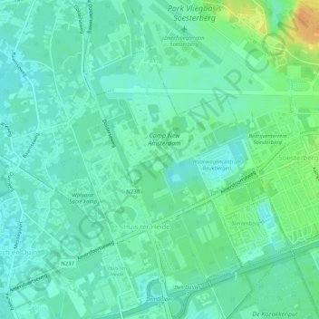
Name: Huis ter Heide topographic map, elevation, terrain.
Location: Huis ter Heide, Zeist, Utrecht, Nederland (52.10498 5.24325 52.13638 5.28234)
Average elevation: 39 ft
Minimum elevation: 10 ft
Maximum elevation: 118 ft
Other topographic maps
Click on a map to view its topography, its elevation and its terrain.
Bosch en Duin
Bosch en Duin, Zeist, Utrecht, Nederland
Average elevation: 30 ft
Slot Zeist
Slot Zeist, slotplein, Zeist, Utrecht, Nederland, 3703DX, Nederland
Average elevation: 20 ft