
Mizoram topographic map
Interactive map
Click on the map to display elevation.
About this map
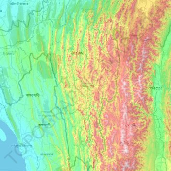
Name: Mizoram topographic map, elevation, terrain.
Location: Mizoram, India (21.94126 92.26022 24.53870 93.43737)
Average elevation: 1,775 ft
Minimum elevation: -3 ft
Maximum elevation: 8,684 ft
Mizoram is a land of rolling hills, valleys, rivers and lakes. As many as 21 major hill ranges or peaks of different heights run through the length and breadth of the state, with plains scattered here and there. The average height of the hills to the west of the state is about 1,000 metres (3,300 ft). These gradually rise up to 1,300 metres (4,300 ft) to the east. Some areas, however, have higher ranges which go up to a height of over 2,000 metres (6,600 ft). Phawngpui Tlang also known as the Blue Mountain, situated in the southeastern part of the state, is the highest peak in Mizoram at 2,210 metres (7,250 ft). About 76% of the state is covered by forests, 8% is fallows land, 3% is barren and considered uncultivable area, while cultivable and sown area constitutes the rest. Slash-and-burn or jhum cultivation, though discouraged, remains in practice in Mizoram and affects its topography. A report by Ministry of Environment, Forest and Climate Change in 2021 states that Mizoram has the highest forest cover as a percentage of its geographical area of any Indian state, being 84.53% forest.
Other topographic maps
Click on a map to view its topography, its elevation and its terrain.
3d
India > Rajasthan > Ganganagar Tehsil > 1 LNP
3d, 1 LNP, Ganganagar Tehsil, Sri Ganganagar District, Rajasthan, India
Average elevation: 584 ft
Parbatpur
India > Madhya Pradesh > Sironj Tahsil > Kamariya
Parbatpur, Kamariya, Sironj Tahsil, Vidisha District, Madhya Pradesh, India
Average elevation: 1,627 ft
Songadh
India > Gujarat > Songadh Taluka
Songadh, Songadh Taluka, Tapi District, Gujarat, 394670, India
Average elevation: 407 ft
Indian subcontinent
India > Maharashtra > Arni
Indian subcontinent, Arni, Yavatmal, Maharashtra, India
Average elevation: 1,155 ft
Mandirbazar
Mandirbazar, South 24 Parganas District, West Bengal, 743336, India
Average elevation: 13 ft
Nankhari
Nankhari, Shimla District, Himachal Pradesh, 172021, India
Average elevation: 6,732 ft
Alamboo
India > Rajasthan > Kekri Tehsil
Alamboo, Kekri Tehsil, Ajmer District, Rajasthan, India
Average elevation: 1,165 ft
Chichkheda
India > Madhya Pradesh > Pandhurna Tahsil
Chichkheda, Pandhurna Tahsil, Pandhurna District, Madhya Pradesh, India
Average elevation: 1,663 ft
Naggar
India > Himachal Pradesh > Kullu
Naggar, Kullu, Kullu District, Himachal Pradesh, 175130, India
Average elevation: 6,699 ft
Morshing
India > Arunachal Pradesh > Kalaktang ADC
Morshing, Kalaktang ADC, West Kameng District, Arunachal Pradesh, India
Average elevation: 7,615 ft
Dehradun
India > Uttarakhand > Dehradun
Dehradun, Dehradun District, Uttarakhand, 248001, India
Average elevation: 2,966 ft
Panchgani
India > Maharashtra > Mahabaleshwar
Panchgani, Mahabaleshwar, Satara, Maharashtra, 412805, India
Average elevation: 3,343 ft
Namgial
India > Himachal Pradesh > Poo district
Namgial, Poo district, Kinnaur District, Himachal Pradesh, India
Average elevation: 10,397 ft
Ranipet
India > Tamil Nadu > Wallajah
Ranipet, Wallajah, Ranipet District, Tamil Nadu, 632401, India
Average elevation: 564 ft
Jinnenahalli
India > Karnataka > Channarayapattana taluk
Jinnenahalli, Channarayapattana taluk, Hassan District, Karnataka, 573135, India
Average elevation: 2,831 ft
Jinnaram
India > Telangana > Kotepally mandal
Jinnaram, Kotepally mandal, Vikarabad District, Telangana, 501106, India
Average elevation: 1,801 ft
Deotsidh
India > Himachal Pradesh > Dhatwal
Deotsidh, Dhatwal, Hamirpur District, Himachal Pradesh, 174030, India
Average elevation: 2,365 ft
Anagalapura
India > Karnataka > Bangalore East > Anagalapura
Anagalapura, Bangalore East, Bengaluru Urban, Karnataka, India
Average elevation: 2,917 ft
Sahastradhara
India > Uttarakhand > Dehradun
Sahastradhara, Dehradun, Dehradun District, Uttarakhand, 248009, India
Average elevation: 3,609 ft
Jagatpur
India > Odisha > Cuttack (M.Corp.) P.S
Jagatpur, Cuttack (M.Corp.) P.S, Cuttack District, Odisha, India
Average elevation: 75 ft
Ward 61
India > Tamil Nadu > Tiruchirappalli
Ward 61, Trichy Zone IV, Trichy Corporation Limits, Tiruchirappalli, Tiruchirappalli District, Tamil Nadu, India
Average elevation: 292 ft
Jabalpur
India > Madhya Pradesh > Ranjhi Tahsil
Jabalpur, Ranjhi Tahsil, Jabalpur District, Madhya Pradesh, India
Average elevation: 1,339 ft
Katangi
India > Madhya Pradesh > Katangi Tahsil
Katangi, Katangi Tahsil, Balaghat District, Madhya Pradesh, 481445, India
Average elevation: 1,135 ft
Nimbora
India > Rajasthan > Sirohi Tehsil
Nimbora, Sirohi Tehsil, Sirohi District, Rajasthan, 307802, India
Average elevation: 866 ft
Gaganbavda
India > Maharashtra > Gaganbavda
Gaganbavda, Kolhapur, Maharashtra, 416006, India
Average elevation: 1,539 ft
Nabagram
Nabagram, Murshidabad District, West Bengal, India
Average elevation: 79 ft
Kallanai
India > Tamil Nadu > Thiruvaiyaru
Kallanai, Thiruvaiyaru, Thanjavur District, Tamil Nadu, 621601, India
Average elevation: 197 ft
Garur
India > Uttarakhand > Garud
Garur, Garud, Bageshwar District, Uttarakhand, 263641, India
Average elevation: 4,035 ft
Rangareddy Palle
India > Telangana > Gandeed mandal
Rangareddy Palle, Gandeed mandal, Mahabubnagar District, Telangana, India
Average elevation: 1,650 ft
Lambgaon
India > Uttarakhand > Pratapnagar
Lambgaon, Pratapnagar, Tehri Garhwal District, Uttarakhand, 249165, India
Average elevation: 4,911 ft
Kalavad
India > Gujarat > Kalavad Taluka
Kalavad, Kalavad Taluka, Jamnagar District, Gujarat, 361160, India
Average elevation: 328 ft
Qasba
India > Himachal Pradesh > Palampur
Qasba, Palampur, Kangra District, Himachal Pradesh, 176083, India
Average elevation: 2,631 ft
Mannanthala
India > Kerala > Thiruvananthapuram
Mannanthala, Thiruvananthapuram, Thiruvananthapuram District, Kerala, 695003, India
Average elevation: 167 ft
Nadbai
India > Rajasthan > Nadbai Tehsil
Nadbai, Nadbai Tehsil, Bharatpur District, Rajasthan, 321602, India
Average elevation: 663 ft
Nelamangala taluk
Nelamangala taluk, Bengaluru Rural, Karnataka, India
Average elevation: 2,913 ft
Nagaur
India > Rajasthan > Nagaur Tehsil
Nagaur, Nagaur Tehsil, Nagaur District, Rajasthan, 341001, India
Average elevation: 994 ft
Mahwa Tehsil
Mahwa Tehsil, Dausa District, Rajasthan, India
Average elevation: 801 ft