
Soest topographic map
Interactive map
Click on the map to display elevation.
About this map
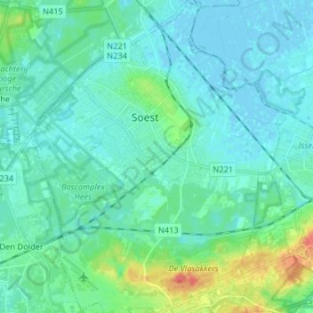
Name: Soest topographic map, elevation, terrain.
Location: Soest, Utrecht, Nederland (52.12423 5.24317 52.20456 5.34993)
Average elevation: 30 ft
Minimum elevation: -10 ft
Maximum elevation: 164 ft
Other topographic maps
Click on a map to view its topography, its elevation and its terrain.
Soesterberg
Soesterberg, Soest, Utrecht, Nederland
Average elevation: 59 ft
Pijnenburg
Pijnenburg, Soest, Utrecht, Nederland, 3763 LD, Nederland
Average elevation: 20 ft
Soestduinen
Soestduinen, Soest, Utrecht, Nederland, 3768 MJ, Nederland
Average elevation: 46 ft
Park Vliegbasis Soesterberg
Park Vliegbasis Soesterberg, Soest, Utrecht, Nederland
Average elevation: 43 ft
Grote Melm
Nederland > Utrecht > Soest > Grote Melm
Grote Melm, Soest, Utrecht, Nederland, 3764AZ, Nederland
Average elevation: 13 ft