
Monte Gordo topographic map
Interactive map
Click on the map to display elevation.
About this map
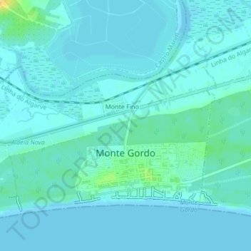
Name: Monte Gordo topographic map, elevation, terrain.
Location: Monte Gordo, Faro, Portugal (37.17553 -7.47302 37.19523 -7.43969)
Average elevation: 13 ft
Minimum elevation: -3 ft
Maximum elevation: 82 ft
Other topographic maps
Click on a map to view its topography, its elevation and its terrain.
Praia de Monte Gordo
Portugal > Faro > Monte Gordo
Praia de Monte Gordo, Monte Gordo, Faro, Portugal
Average elevation: 10 ft