
Vila Viçosa topographic map
Interactive map
Click on the map to display elevation.
About this map
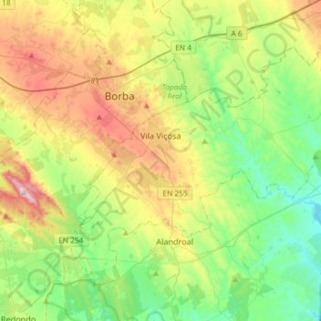
Name: Vila Viçosa topographic map, elevation, terrain.
Location: Vila Viçosa, Évora, Portugal (38.67123 -7.49999 38.84802 -7.20738)
Average elevation: 1,024 ft
Minimum elevation: 476 ft
Maximum elevation: 2,060 ft
Other topographic maps
Click on a map to view its topography, its elevation and its terrain.
Reguengos de Monsaraz
Reguengos de Monsaraz, Évora, Portugal
Average elevation: 679 ft
Alqueva
Portugal > Évora > Amieira e Alqueva
Alqueva, Amieira e Alqueva, Portel, Évora, 7220-028, Portugal
Average elevation: 627 ft
Alcáçovas
Portugal > Évora > Viana do Alentejo > Alcáçovas
Alcáçovas, Viana do Alentejo, Évora, Alentejo Region, Portugal
Average elevation: 558 ft