
Lyttelton topographic map
Interactive map
Click on the map to display elevation.
About this map
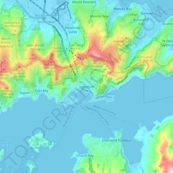
Name: Lyttelton topographic map, elevation, terrain.
Average elevation: 325 ft
Minimum elevation: -10 ft
Maximum elevation: 1,814 ft
Other topographic maps
Click on a map to view its topography, its elevation and its terrain.
Ohinepaka Bay
New Zealand > Canterbury > Christchurch City > Banks Peninsula Community > Wainui
Ohinepaka Bay, Wainui, Banks Peninsula Community, Christchurch City, Canterbury, 7582, New Zealand
Average elevation: 308 ft
Zig Zag
New Zealand > Canterbury > Christchurch City > Banks Peninsula Community
Zig Zag, Banks Peninsula Community, Christchurch City, Canterbury, New Zealand
Average elevation: 446 ft