
Merelbeke topographic map
Interactive map
Click on the map to display elevation.
About this map
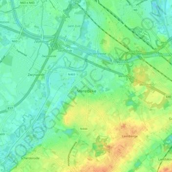
Name: Merelbeke topographic map, elevation, terrain.
Location: Merelbeke, Gent, East Flanders, Flanders, 9820, Belgium (50.96484 3.71110 51.02725 3.77918)
Average elevation: 43 ft
Minimum elevation: 0 ft
Maximum elevation: 121 ft
Other topographic maps
Click on a map to view its topography, its elevation and its terrain.
Munte
Belgium > East Flanders > Gent > Merelbeke
Munte, Merelbeke, Gent, East Flanders, Flanders, Belgium
Average elevation: 108 ft