
Sint-Truiden topographic map
Interactive map
Click on the map to display elevation.
About this map
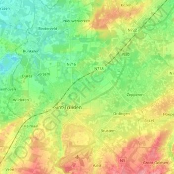
Name: Sint-Truiden topographic map, elevation, terrain.
Location: Sint-Truiden, Hasselt, Limburg, Flanders, Belgium (50.77642 5.14971 50.87732 5.24488)
Average elevation: 177 ft
Minimum elevation: 66 ft
Maximum elevation: 331 ft
Other topographic maps
Click on a map to view its topography, its elevation and its terrain.
Zepperen
Belgium > Limburg > Hasselt > Sint-Truiden
Zepperen, Sint-Truiden, Hasselt, Limburg, Flanders, Belgium
Average elevation: 171 ft