
Paal topographic map
Interactive map
Click on the map to display elevation.
About this map
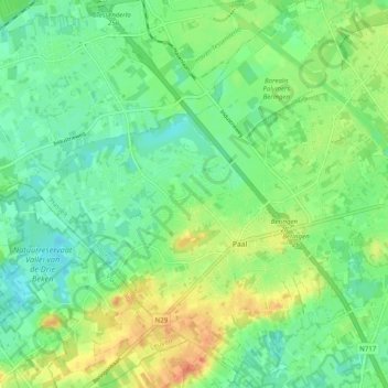
Name: Paal topographic map, elevation, terrain.
Location: Paal, Beringen, Hasselt, Limburg, 3583, België (51.01637 5.12153 51.07875 5.21185)
Average elevation: 102 ft
Minimum elevation: 43 ft
Maximum elevation: 190 ft
Ook ten zuiden van de kom van Paal ligt een reeks getuigenheuvels tot 50 meter hoogte, die de rechteroever van de Zwarte Beek omzomen.
Other topographic maps
Click on a map to view its topography, its elevation and its terrain.
Beringen-Mijn
België > Limburg > Hasselt > Beringen
Beringen-Mijn, Koersel, Beringen, Hasselt, Limburg, 3582, België
Average elevation: 118 ft