
Nieuwpoort topographic map
Interactive map
Click on the map to display elevation.
About this map
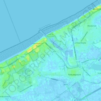
Name: Nieuwpoort topographic map, elevation, terrain.
Location: Nieuwpoort, Veurne, West Flanders, Flanders, 8620, Belgium (51.12353 2.69981 51.16486 2.79877)
Average elevation: 7 ft
Minimum elevation: -13 ft
Maximum elevation: 69 ft
Other topographic maps
Click on a map to view its topography, its elevation and its terrain.
Ramskapelle
Belgium > West Flanders > Veurne > Nieuwpoort
Ramskapelle, Nieuwpoort, Veurne, West Flanders, Flanders, 8620, Belgium
Average elevation: 3 ft