
Lede topographic map
Interactive map
Click on the map to display elevation.
About this map
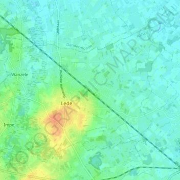
Name: Lede topographic map, elevation, terrain.
Location: Lede, Aalst, Oost-Vlaanderen, Vlaanderen, België (50.95256 3.94513 50.98717 4.02404)
Average elevation: 46 ft
Minimum elevation: 16 ft
Maximum elevation: 125 ft
Other topographic maps
Click on a map to view its topography, its elevation and its terrain.
Oordegem
België > Oost-Vlaanderen > Aalst > Lede
Oordegem, Lede, Aalst, Oost-Vlaanderen, België
Average elevation: 79 ft
Wanzele
België > Oost-Vlaanderen > Aalst > Lede
Wanzele, Lede, Aalst, Oost-Vlaanderen, Vlaanderen, België
Average elevation: 52 ft
Impe
België > Oost-Vlaanderen > Aalst > Lede
Impe, Lede, Aalst, Oost-Vlaanderen, Vlaanderen, 9340, België
Average elevation: 72 ft