
Mohácsi járás topographic map
Interactive map
Click on the map to display elevation.
About this map
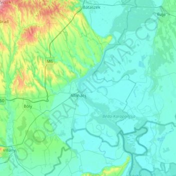
Name: Mohácsi járás topographic map, elevation, terrain.
Average elevation: 390 ft
Minimum elevation: 259 ft
Maximum elevation: 1,339 ft
Other topographic maps
Click on a map to view its topography, its elevation and its terrain.
Magyaregregy
Magyaregregy, Komlói járás, Baranya, Southern Transdanubia, Transdanubia, 7332, Hungary
Average elevation: 942 ft
Mohácsi Történelmi Emlékhely
Mohácsi Történelmi Emlékhely, 8, Sátorhely, Mohácsi járás, Baranya, Southern Transdanubia, Transdanubia, 7785, Hungary
Average elevation: 299 ft
Magyarmecske
Magyarmecske, Sellyei járás, Baranya, Southern Transdanubia, Transdanubia, Hungary
Average elevation: 338 ft
Hosszúhetény
Hosszúhetény, Pécsi járás, Baranya, Southern Transdanubia, Transdanubia, 7694, Hungary
Average elevation: 1,119 ft
St. Lawrence
Hungary > Baranya > St. Lawrence
St. Lawrence, Szentlőrinci járás, Baranya, Southern Transdanubia, Transdanubia, 7940, Hungary
Average elevation: 433 ft