
Tahiti topographic map
Interactive map
Click on the map to display elevation.
About this map
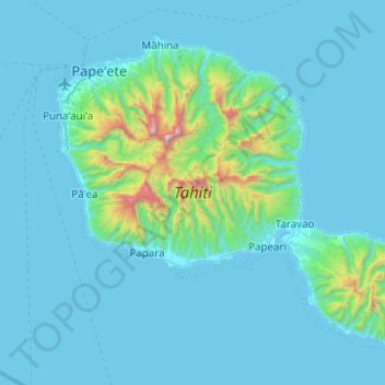
Name: Tahiti topographic map, elevation, terrain.
Location: Tahiti, Windward Islands, French Polynesia, France (-17.88036 -149.62090 -17.49417 -149.12469)
Average elevation: 525 ft
Minimum elevation: 0 ft
Maximum elevation: 7,018 ft
Other topographic maps
Click on a map to view its topography, its elevation and its terrain.
Pāʻea
France > French Polynesia > Windward Islands
Pāʻea, Windward Islands, French Polynesia, 98711, France
Average elevation: 827 ft
Mo’orea
France > French Polynesia > Windward Islands
Mo’orea, Windward Islands, French Polynesia, 98729, France
Average elevation: 282 ft
Faʻaʻā
France > French Polynesia > Windward Islands
Faʻaʻā, Windward Islands, French Polynesia, 98704, France
Average elevation: 1,135 ft