
Vill topographic map
Interactive map
Click on the map to display elevation.
About this map
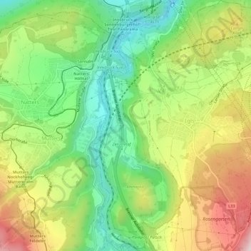
Name: Vill topographic map, elevation, terrain.
Location: Vill, Innsbruck, Tirol, Österreich (47.21208 11.38732 47.24851 11.41604)
Average elevation: 2,713 ft
Minimum elevation: 1,972 ft
Maximum elevation: 3,737 ft
Other topographic maps
Click on a map to view its topography, its elevation and its terrain.
Innsbruck
Österreich > Tirol > Innsbruck
Innsbruck, Statutarstadt Innsbruck, Tirol, Österreich
Average elevation: 2,005 ft
Igls
Österreich > Tirol > Innsbruck
Igls, Innsbruck, Tirol, 6080, Österreich
Average elevation: 2,920 ft