
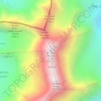
Mount Cook topographic map
Interactive map
Click on the map to display elevation.
About this map
Name: Mount Cook topographic map, elevation, terrain.
Location: Mount Cook, Mackenzie District, Canterbury, New Zealand (-43.59505 170.14212 -43.59495 170.14222)
Average elevation: 9,580 ft
Minimum elevation: 7,333 ft
Maximum elevation: 12,169 ft
Temperatures at the mountain's base in the Hooker Valley around 800 metres (2,600 feet) range from −13 °C (9 °F) to 32 °C (90 °F), and generally fall just over 1 °C for every 200 metres of altitude.
Other topographic maps
Click on a map to view its topography, its elevation and its terrain.
Mount Blackburn
New Zealand > Canterbury > Mackenzie District
Mount Blackburn, Mackenzie District, Canterbury, New Zealand
Average elevation: 5,361 ft
Twizel
New Zealand > Canterbury > Mackenzie District
Twizel, Mackenzie District, Canterbury, 7901, New Zealand
Average elevation: 1,549 ft
Burkes Pass
New Zealand > Canterbury > Mackenzie District > Burkes Pass
Burkes Pass, Mackenzie District, Canterbury, New Zealand
Average elevation: 2,041 ft
Lake Benmore
New Zealand > Canterbury > Mackenzie District
Lake Benmore, Mackenzie District, Canterbury, New Zealand
Average elevation: 2,444 ft
Lake Tekapo
New Zealand > Canterbury > Mackenzie District
Lake Tekapo, Mackenzie District, Canterbury, New Zealand
Average elevation: 3,363 ft
Fairlie
New Zealand > Canterbury > Mackenzie District
Fairlie, Mackenzie District, Canterbury, 7925, New Zealand
Average elevation: 1,040 ft
Tasman Lake
New Zealand > Canterbury > Mackenzie District
Tasman Lake, Mackenzie District, Canterbury, New Zealand
Average elevation: 3,478 ft
Lake Pukaki
New Zealand > Canterbury > Mackenzie District
Lake Pukaki, Mackenzie District, Canterbury, New Zealand
Average elevation: 2,907 ft