
Kadapa topographic map
Interactive map
Click on the map to display elevation.
About this map
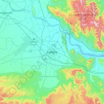
Name: Kadapa topographic map, elevation, terrain.
Location: Kadapa, YSR, Andhra Pradesh, 516001, India (14.31529 78.66169 14.63529 78.98169)
Average elevation: 843 ft
Minimum elevation: 335 ft
Maximum elevation: 2,671 ft
Kadapa is located at 14°28′N 78°49′E / 14.47°N 78.82°E / 14.47; 78.82 about 412 km from Hyderabad, 260 km from Chennai, 250 km from Bangalore and 360 km from Vijayawada in the Rayalaseema region of Andhra Pradesh.[5] The city is situated in the Bugga vanka or Ralla Vanka rivers bordered by the Palakondas to the south and to the east by a patch of hills casting north for the Lankamalas on Penna's other side.[6] It has an average elevation of 138 metres (452 ft).[7] Veligonda hills separates the districts of Nellore and Kadapa.[8]